Monday, December 27, 2010

Utah October 7-17th 2010

Susan and I returned to Utah for more canyoneering, climbing and desert rambling. Severe thunderstorms had filled and flooded all the slot canyons with freezing water and hail stones so we made our way to Page Arizona where we spent the better part of 4 days hanging out waiting for things to dry out.

Horseshoe Bend near Page


Glen Canyon Dam


Susan and the night sky at Valley of the Gods


Susan at the second pitch belay on Jimmy Durante Snow Canyon


On October 16th we geared up for a climb up Lady Mountain in Zion National park. We met a guy named Steve just below the first pitch who was making his third attempt on the peak. Susan and I stashed our rope and Steve dumped some of his gear, we teamed up and five hours later we were on top.

Upper Zion from half way up Lady Mt.

Wednesday, August 25, 2010

Sawtooths August 5-8th

In late July, Riann, Susan and I tramped a grueling 10 mile loop to Alice Lake and back during the hottest part of the day. None of us had been there before but I knew I’d have to return for a photo or two. Two weeks later, Susan and I stayed a stormy night on the lake during a longer loop hike. Here are a few shots from a trip where the weather behaved splendidly.

El Capitan peak over Alice Lake.


Cascades near camp below Alice lake


Afternoon Storm building

This little thunderstorm was a harbinger of things to come and during the night we got hit with the real thing. At about 2am, we got to witness a short but frighteningly intense storm. With the first clap of thunder, I gathered my gear and sprinted to the lake. I shot three photos hoping to catch a nice ground strike but the bolts of lightening were so close and fat they completely overexposed my cameras sensor. When the rain started, it came in buckets and I ran for the tent too late. First the rain, then it hailed while lightening flashed constantly for about 15 minutes.


Lightening, rain and mist

I got several photos of cloud to cloud lightening as the storm rolled out the cirque and down the canyon. It's intensity died almost as quickly as it started. (click to enlarge)


Alice Lake at Dawn.
The next morning I woke up at first light to the sound of light rain falling on the tent. Disappointed, I listened for several minutes thinking I was out of luck on getting a photo, but When I unzipped the tent I was happily surprised.


Sawtooth reflection.
On the small lake below Alice Lake.

Monday, June 21, 2010

Mt. Church N. Face ski 6-19-10

Here are a few photos of an impromptu ski trip off of Mt. Church on Saturday. I’d been planning it and waiting for the weather to settle for nearly a month but Brando ditched work immediately when I invited him along at the last minute.

Three hours of driving took us to the end of the road in the east fork of Upper Pahsimeroi and after another three hours of hiking through heavy timber we arrived at the 9700’ mouth of the massive Mount Church cirque. We set up camp near a large tarn just past the mouth and enjoyed what was left of the day, watching evening shadows chase the light up our impending route.

At 4am I started melting snow for coffee and extra water, we ate and got dressed in a very leisurely fashion and then started climbing at 05:28, three hours later we were eating lunch on the summit.

Skinning into the mouth of the cirque,
Mount Church dominates the background. We set up camp just beyond.


Brandon puts the finishing touches on his sleeping gear.
The tarn, viewed just below his left knee is starting to show signs of melting.


Climbing out of the shadows.
I was only able to skin to about 10,500’ The recent snow left a thin veneer of crust on the surface and even my ski crampons wouldn’t bite in. Those same conditions made for easy boot-packing though.


Navigating the ridge. I’ve been up this ridge enough times to know how steeply it drops off the SW side so I was a little worried about topping out on an overhanging cornice, and although the ridge is riddled with them, we lucked out.


Brandon nearing the top.
He was super fit and stoked on this, his second trip to the top. He and I teamed up for a standard-route-winter climb a few years earlier that turned into a 17 hour truck to truck epic march in high winds and bad snow.


Ahhh, the summit!
Hitting the eject button on my pack was pretty gratifying, we spent 45 minutes on top taking in the scene and eating lunch. A 3mph breeze coming out of the west was welcome company after the stifling conditions on the East face.


Brandon, Big Stepping just below the top.
He’s not a skier but made very good time coming down.


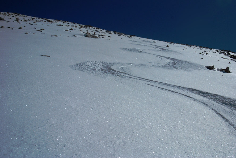
Descending the North face.
We climbed and descended the same
route Marc Hanselman
Did on May 17th The skiing was amazing! The little pinwheels in this photo had come off the day before and were a little crusty but I only had to ski through a short section of them. Definitely another Hard to reach Idaho classic ski!

Tuesday, May 18, 2010

Diamond Peak 5-14-10

A few photos from Friday on Diamond Peak. This was my second try at skiing it; the first time was a few years ago in early March with Steve. We ran into bad conditions on the face and continued on after abandoning the boards pretty low on the ridge. For me, Diamond is one of the safest winter or spring 12er to climb but I always suspected skiing its East face would be the absolute opposite.

On Thursday, my climbing partner had to bail at the last minute and I decided it would be too risky to stick with an East face descent without a lifeline and I was more than a little relieved to set my sights on the South face.

I was able to drive all the way to the trail head and after a short hike, spent a comfortable night on the ridge at 9,300’ The climb to the top wasn’t what I’d expected, a lot of the snow was punchy (sometimes all the way to my waist) and I was pretty worked by the time I hit the top. The weather couldn’t have been better though, mostly sunny and totally windless. I recuperated for about an hour and then set off down the huge and wide open South face. The snow conditions were as good as the weather and I made effortless turns in perfect corn on an aspect that is probably less than 40 degrees. Easily the best ski down any of the 12ers I’ve yet had!


Camp on the ridge below the East face.


Evening light on alluvial ridges below camp

Just below the summit from the East ridge.

On the top.


>

Tuesday, April 27, 2010

Close call on DBE / 5-19-09

The iconic North face of Devil’s Bedstead East is becoming a benchmark for Idaho ski mountaineering. No surprise, it has all the makings; remote, steep, tall and hulking.
Brad Chilton, David Scott and I overnighted about a mile from the trailhead on the 18th of May. In the morning, we headed out under a star studded sky and made slow progress in mushy snow till we were able to pull on our ski boots and start skinning at about 8,800’. From there we made good time until it got too steep for the skis. From there we slogged in crampons up steep breakable crust till we made it to the North East ridge where we got a break from the exhausting crust by climbing on the super exposed edge of windblown cornices draping the immense void of the East face. To complicate things, our bluebird day had deteriorated to occasional snow showers and gusty winds. I was supremely confident however and certainly no stranger to climbing along steep cornices in bullying breezes, so when the whole works came out from under me, I was reduced to staring in cow-eyed stupidity as tons of snow dropped several yards onto a steep ramp at the top of the face. When it hit, the snow covering the ramp avalanched and the whole hullabaloo plunged down the slope for about 120 feet where it slammed into a steep buttress forming the right side of a choke point that spilled over the massive cliff face. The rolling noise dominated even the wind as the snow rocketed out into space. After it was over, I was mesmerized by the scene, 40’ of cornice in front of me and 25’ behind me had sheared off and unzipped right between my feet, taking 12 of my footprints with it. A valuable but embarrassing lesson. I can’t think of a scenario where one can come so close to dying without getting a scratch.

David looks at the summit and our ski line. Here, we had the choice of climbing over rocks in our ski boots or punching up breakable crust. We made our way over to the ridge where the going got much easier.


Brad climbing the North East Ridge just below the site of the cornice collapse


The awesome East face of Devils Bedstead East in the distance. The accident happened a couple hundred feet below the summit on the right side ridge. This photo was taken while on a failed attempt at climbing Brocky peak with Brad in 2007.

Sunday, March 28, 2010

This one has been on my “winter list” for a few years now but weather, conditions, laziness and timing have stymied all previous opportunities. This season has been plagued by those same obstacles and although I missed winter by a week, the weather on the approach was far from spring-like.

End of the line. I parked at the turn off to Wildhorse canyon and snowmachined the 10or so miles to the trailhead. This photo really shows my style of riding, always stuck or about to be stuck. It also shows a few of the feeble layers in the snowpack.


Breaking weather. I set up camp in what felt like a safe spot on the lower slopes of the north face. (visibility was only a couple hundred feet) The wind blew a steady 20+ mph but died off as the clouds started to break and then quit completely by midnight. Hyndman peak just visible through the clouds


10 years ago, I trusted the weatherman about as much as an army recruiter but these days forecasting is usually spot on and I wasn’t surprised at all to wake up and see it bluebird.


I got to the summit at 11:00am after a slow and easy 3 hour skin. Zero wind and warm sunshine made it hard pretty to leave the view. This photo shows the true highpoint left on the ridge but there sure as hell aren’t any good ski lines off of it.


I’d hoped to ski down the large gully on the west face but an enormous avalanche had flushed out most of the snow and deposited it in massive pile on the plateau at 9,600’. I checked out a chute on North West face that had a heavy blanket of blown in snow. However, the top 3rd was a rock strewn 55* and the bottom had a definite terrain trap look about it so I settled on eeking my way down the West face through a minefield of boulders in 4” of new snow over hardpack. The turns were effortless even after a long pair of days. Hope that’s not the last powder day of the season!

Friday, March 12, 2010

The Hunt is On! March 2010

So many consecutive 40-ish degree days can only mean Spring is rearing it's ugly head and our days of deep and soft are coming to an end. The powder snob in me has mostly learned to clam up when my non skiing comrades start pissing on about the mud, the new snow, the cold, etc. The hunt is on for those ever dwindling stashes of hold out freshies.
After a relatively wind-free winter, those westerly breezes are saving the day. Here are a few photos of the last 4 days on the Southern tip of the Pioneers.


Monday, conditions were pretty demoralizing on the way up Fly-boy ridge but the stuff blown into Recovery bowl was worth several laps.


We remotely triggered a good portion of the top of this bowl two days earlier and skied through the debris while it was still soft. On the second lap the snow had built up again and we decided to find safer snow. Some time that night it let go again blasted all the way to the bottom. the skiing was still good near the edges on Tuesday


Wednesday, Sticking the landing on Taco

Thursday, Eric Taking a well earned break on lap 7 at the top of Chicken Run. The wind seemed to have no influence on his mood.

Wednesday, March 10, 2010

Mt. Corruption 5-1-2007


Star trails over Mt. Corruption. (this is an 18 minute exposure)Shot from Ferd's Cabin.


Brad and Brandon descend the ridge back toward camp, The Lost river range dominates the background. Mt
. Borah's East ridge climbs the upper left side of the photo.


Camp at 10,400 feet on the South West flank of Corruption.

Thursday, March 4, 2010

Corona Arch 10-5-09

Susan and I spent enough time skulking around Moab’s climbing locals to learn a few of their best kept secrets including hidden slot canyons, cool climbs and weird stuff to do when you’re bored. The Corona Arch rappel fit into the last category and although we weren’t bored we couldn’t pass up a chance to see it from the top down.

A short hike over vast terraces of unspoiled sandstone lead to this partially freestanding arch, the opening is 140’ by 105’ and the climb to the top requires an easy but crazily exposed class climb protected by 7 or 8 pitons. We dim-wittedly left our second rope in the truck and I paid the penalty by having to repeat the climb sans cord.


After the rappel, we tied back in and turned the setup into a giant rope swing.

Susan roped up at the top of the class 4 section.

Monday, March 1, 2010

Skiing Hyndman Peak

On January 27, 2008. Steve, Cassie, Eric, Susan and I made the hike into the Pioneer Mountains with the hopes of climbing and Skiing Idaho’s 9th highest peak. An intense winter storm followed us all the way to the trailhead and by the time we got to the yurt, 10” of new snow had fallen, by the next morning more than two feet of new powder put an end to our plans. The avalanche cycle following the storm made travel outside the hut pretty treacherous. We stayed two more nights letting the snow settle and then made our way back out to the truck. On March 18th, we returned and made it to the top on the following day and skied back in weather that once again shut down the mnountains.
Steve and Cassie climbing above the saddle, Old Hyndman Peak in the background.

The Pioneer Yurt at night.

Wednesday, February 24, 2010

The Fins

The Fins, a scattered collection of limestone ridges located a few miles out of Arco, make for easy access to hard climbing. I mostly thrutch around like a fool and then watch others seemingly defy gravity on nonexistent holds. The two shots below show Steve on the Discovery Wall.


Mt. Shuksan, North Cascades- Washington

Although I’d seen the North Cascades many times, the first time I was really staggered by their grandeur was from the window of an Alaskan Airlines 737 on a trip to Mexico. I set my sights on the (my opinion) most impressive plumb in the range, Mount Shuksan. A year later I made it to the top in deteriorating weather that prevailed for 8 more days and stymied my attempts on two other mountains in the area.
4 tiny climbers make their way across the upper Sulphide Glacier to the summit head wall.

The summit. Although the weather was perfect on top, the thick clouds on the left side of the photo settled in for the next 8 days. I navigated my way back to high camp through thick fog, using the GPS I'd luckily brought along.

Tuesday, February 23, 2010

Skiing Mt. Borah's North face. 7-23-09


On July 24th, 2009 Brandon Hobbs and I climbed the standard route on the South West side of Mt. Borah. It had been a pretty average winter but I'd noticed the snow was hanging tough on the north face. Dooley and I had climbed the face in 2005 and at the time I'd not considered it as a a possible ski route, the summit couloir is steep and too narrow for any real turns, the upper face has a double fall-line and  and much of the terrain forces you to continually ski left to avoid rocky outcroppings. The other - West side of the mountain looks like much easier skiing but has a good deal double fall-line as well. In general I'd always considered a ski descent off any aspect of the mountain as "not worth the pack-weight to ski-turn ratio" but as I knocked over one 12'er after the next Borah finally got in the way. The hike up that morning on the standard rout's well beaten trail turned out to be easier than I'd hoped for and the weather was perfect.
Skis, boots, 60 meter rope, etc weighed a little more than 50 lbs so the battle was pretty much over when we made it to the top. The skiing below the chute was just what I'd expected, steep and stiff, and leaning left I could link three or four turns and then side hill to the left before making a few more. In the end, I was able to ski all the way to the old snowtell wreckage at the base of the face. The hike out of Rock Creek is always pleasant and there isn't much bushwacking if you know the way. I knew Brandon would be a while making his way down the mountain and then driving over to pick me up so I had plenty of time to realize that although the turns weren't great, the adventure meant a lot.   
Borah's North face from Double Springs Pass Road. The summit couloir, hardly visible in this long shot, splits the summit dome for the first 200' to the upper snow field. I shot this photo in 2007 and that's when the idea of a NF descent really started to hatch. 

Roped skiing down the summit couloir. The first 250’ of the North face is guarded by a couloir choked with ice and rock. In July, the skiable terrain narrows to less than 2’ in the chute and is steep enough to make it impossible, at least for me. Brandon was able to belay me for the first 160’ but after I pulled the rope, I tried to build an ice bollard for a rappel down the final 90’. The ice was too rotten and brittle for anything but a psychological anchor and I wound up burying and leaving a new snow picket instead. Once out of the couloir, I made rickety turns down the steep sun hammered face producing small "point" avalanches that turned frighteningly large by the time they squeezed between cliff bands. This trusty pair of first generation Black Diamond Verdicts has been with me on every other 12-er descent and although I worried the chute would be the end of them they held up just fine, I still ski them today.

Dooley follows up the face in 2005

Monday, February 22, 2010

Carcass Cliff

Carcass Cliff September 2009. Carcass Cliff near the head of Pass Creek narrows holds some potential for good routes and the exposure adds it’s own element, but loose blocks near the top would have to be trundled off to make it somewhat safe.
Susan pulling over the top, Pass Creek road snakes out of the canyon below.

Carcass rock isn't very Conducive to rope health. The rock is razor sharp, which makes for effective foot work, but a fall can easily damage both your rope and your hide.